Footprints Across Scotland
Why not make a few of your own!
24th May 2008
A journey into the centre of the Cairngorm national park, to visit the Devil the Angel and beyond.
I was up for a long walk and that's exactly what I got, with a bit of cycling thrown in for good measure at either end of the day. The wind had blown away the clouds and blue skies brightened my way through the pines that surround the Linn of Dee. Deer were enjoying breakfast on the open grassland in glen Lui far enough away from the landrover track to be undisturbed.
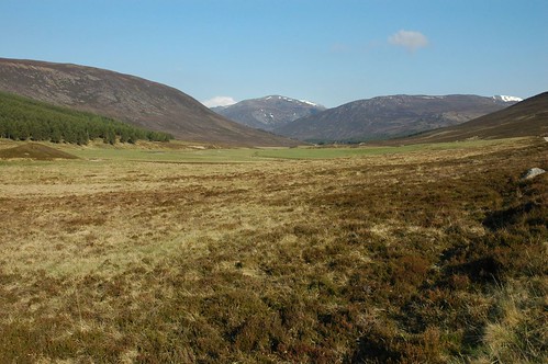
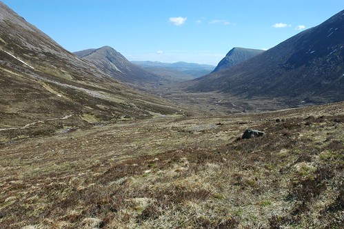
Glen Lui
Happy campers were also enjoying the early morning brightness as I reached Derry lodge. Crossing the flat moor beyond I headed for Glen Luibeg, a Plover tried to distract me from my path by feigning a broken wing. Younger tress outshone their more ancient cousins with lush green pine needles at the Luibeg burn.

The big and the small
More campers were preparing for their day as I crossed the burn, while on the far bank a rucksack lent against a tree waiting for its owner to rise from a zipped up tent. Good paths, although a bit rocky in places, led around the hillside into more open country. Some mountain tops were coming into view as I headed into the Lairig Ghru, the old mountain pass that connects Deeside to Speyside. I was soon greeted with the tremendous sight of the Devils point, very conical in shape when first coming into view.
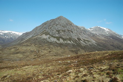
The Devils point
As I progressed up the Lairig Ghru this impressive hill started to became slightly dwarfed by its huge neighbours. Dropping a little I crossed the river Dee by the Cairngorm Club footbridge to reach Corrour bothy.
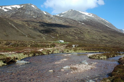
Corrour Bothy
A number of overnight residents had made use of the grassy surrounds to pitch their shelters. Leaving them to their brews it was now time to gain some elevation. A good path behind the bothy eased my way up onto higher ground, crossing a narrow band of snow near the ridge line. Shale and grit made way to the first one of many boulder fields that I would cross. These seem to be a common feature in the Cairngorms, providing a rocky skirt around many of summits. Working my way up through and over the boulders I soon reached my first top of the day, Devils point. After some nuts and dried fruit I detoured slightly to look into Glen Geusachan, a couple of Ptarmigan ambled around me as I made my way.
Glen Geusachan and Beinn Bhrotain
The main hills, some of the UK's biggest, now lay ahead. Working up the rocky hillside using the small strips of turf and short heather were possible I headed for Cairn Toul. More rock hoping was required before reaching the top. The effects of the wind had varied greatly along the way, sometimes hardly noticeable and at others funnelled into strong gusts. Thankfully the top of Cairn Toul was not so windy and I settled down behind the Cairn to enjoy lunch.
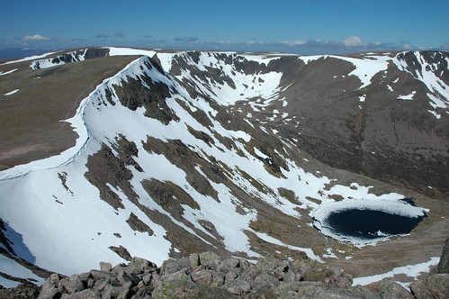
Braeriach
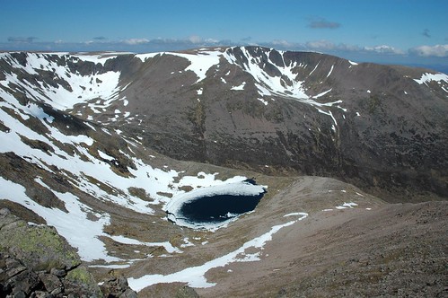
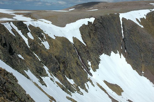
Although well into May plenty of snow still clung to the upper rims of the corries painting the edges white and defining the boundary between plateau and cliff face. The vantage point gave great views into the heart of Braeriach's corries and allowed me to survey the way ahead, a long arc around the high plateau. First though it was time to drop down off Cairn Toul and ascend Sgor an Lochain Uaine (The Angels peak). Between these two tops, nestled in the corrie, Lochan Uaine was still part covered in snow.
Sgor an Lochain Uaine
The ascent and steady descent of Sgor an Lochain Uaine provided much less rocky going and it was back onto a more gravely surface, which made for nice easy walking. A gentle rise saw me gain the Braeriach plateau, passing another Ptarmigan and some fellow walkers on the way.
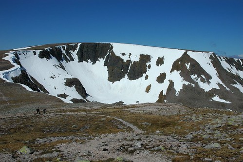
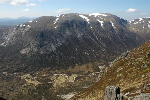
Braeriach and Coire Beanaidh
I followed the path that contours the cliff edge for a time before heading off across flattish tableland to get a view of Sgor Gaoith and Loch Einich below.
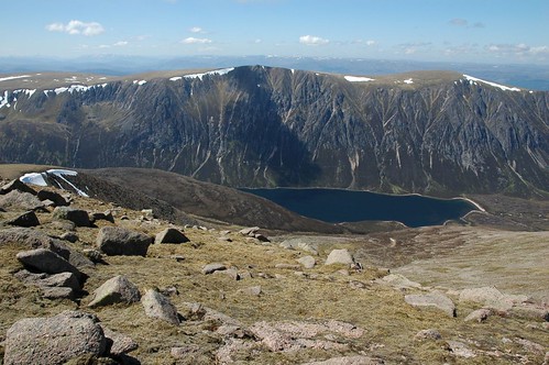
Sgor Gaoith and Loch Einich
I then returned to Braeriach's Corrie edge via the source of the river Dee, the wells of Dee. The waters from the wells flow slowly to the falls of Dee to tumble many hundreds of meters down into Coire Ruadh.
The falls of Dee
It was now just a short hop, skip and boulder jump to reach the furthest top of my walk, the summit of Braeriach itself. Another cuppa was enjoyed as I soaked up the views and sunshine that would redden my face for a few days ahead. Continuing on I followed the outward path to Aviemore for a short while before dropping off over steep rough ground to gain the upper reaches of the Lairig Ghru. I joined just below the pools of Dee and little below the top of the pass, which lies at over 800m.
Down the Lairig Ghru
A long sloping track took me back down to join my outward path near Corrour bothy, it was then around the lower slopes of Carn a' Mhaim and back to the Luibeg burn. After recovering my bike from the heather it was a nice cycle back to the car, giving rest to my feet which by now realised they had covered a fair few K during the days tramp. Some deer were feeding on flat area near Derry lodge and seemed not the least bit concerned as I cycled past within 20m of them, the occasional cursory glance was all I got. I was soon back at the car thankful that the bike had helped to ease the last section of the journey.
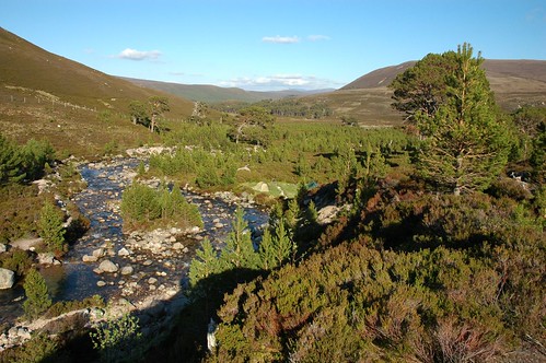
Luibeg burn looking toward Linn of Dee
Top Of Page
site info
© 2007-2008 Paul Sammonds. Template Design by Andreas Viklund.