Footprints Across Scotland
Why not make a few of your own!
11th to 13th April 2009
A few days spent way up north in Sutherland.
Route Map
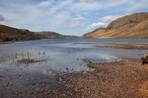
It was to be my first camping trip of the year and I decided to spend it up in the wild and rugged county of Sutherland in the far north of Scotland. Two hills in particular held my fancy, Foinaven (White Mountain) and Arkle (Peak of the chest), but a third, Meall Horn, was also near by. Bealach Horn seemed a suitable spot to camp being conveniently placed between the hills. The drive north took me through Inverness and over the Black Isle to Bonar Bridge before heading for Lairg. From Lairg I then followed the single track road along the shores of Loch Shin, the largest loch in Sutherland at 17 miles long. The falls of Shin to the south of the Loch provide a great viewpoint to see Atlantic salmon as they make their way back to the Loch to spawn. As I travelled higher up the shore Ben More Assynt could be seen still snow topped across the Lochs dark waters.
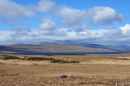
Ben More Assynt across Loch Shin
The road winds between the hills along Loch Merkland and Loch More before reaching Loch Stack. Shortly after Achfary and before reaching Loch Stack I turned off the road and parked at the second of two small car parks. After making final preparations and allowing a couple of showers to pass it was time for the off. Crossing the river that connects Loch Stack and Loch More I began heading up the estate track and passed a house and out buildings at Airdachuilinn. The way continues to a couple of farm buildings and a bridge at Lone. The wind was shifting the clouds quickly across the skies but there was plenty of sun to be had as I enjoyed the views back across Loch Stack to Ben Stack. Up ahead the rocky lines of Arkle provided plenty of interest.
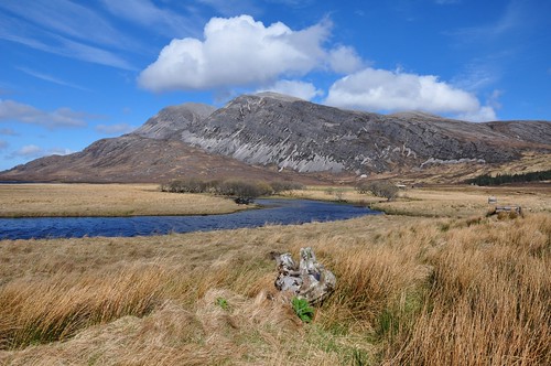
Arkle from near Lone
A small wood whose entrance is marked by what looks like a huge boulder split in two signaled the start of the climb up to Bealach Horn.
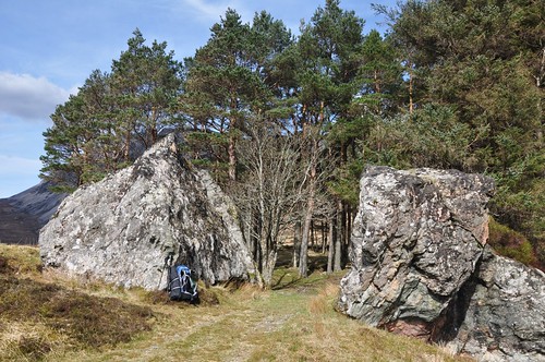
Gateway to the hills and bealach Horn
A short way after leaving the wood I passed a small cairn marking the normal ascent route to Arkle. The excellent path followed Alt Horn as it wove its way between the lower slopes of Arkle and Creachan Thormaid.
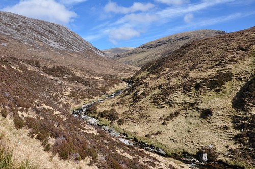
The climb to Bealach Horn alongside Alt Horn
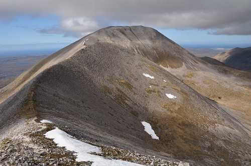
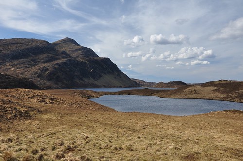
Before arriving at the top of Bealach Horn at around 400m I left the path to look for a camp spot. I worked my way across the boggy hillside to the northern end of the smaller of two lochans. A small area of grass provided enough room to squeeze in my tent and gave fine views across to the eastern corries and scree covered slopes of Arkle. The strong wind had the tent flapping about but I soon had it in place managing not to loose anything on the breeze. Camp gear in place I now set off for a closer look at Arkle.
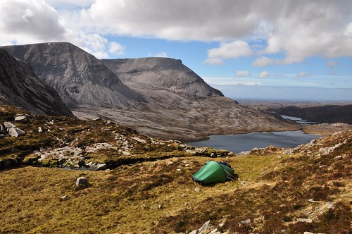
Arkle from camp
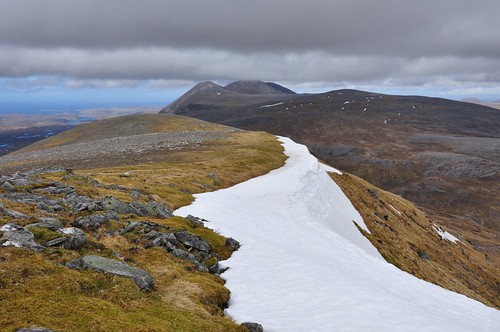
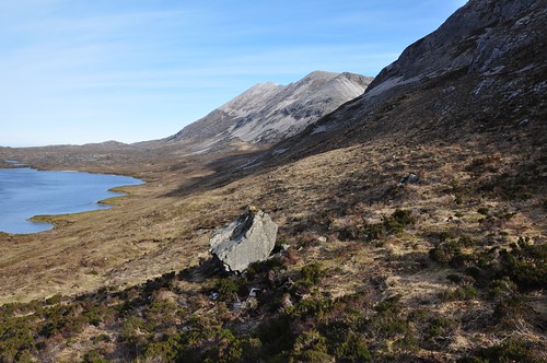
I took a line that would lead me to the top of Meall Aonghais trying to keep to the rock seams and avoid looser rock were possible. It was pretty rough going at times but Lochan na Faoileige was a pleasant distraction nestled as it was on the rocky hillside.
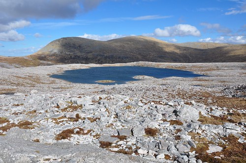
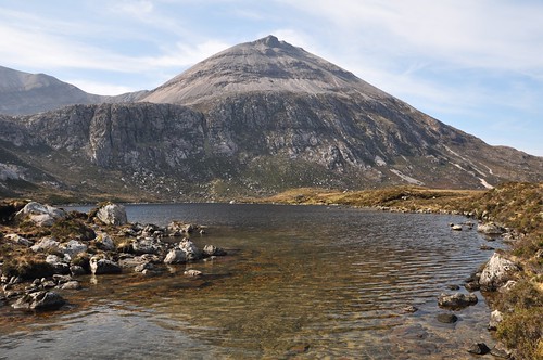
Meal Horn across Lochan na Faoileige
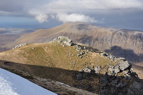
From Meall Aonghais a deep narrow gorge pointed the direction to Arkle's south east top. The wind along this section was now extremely strong making walking difficult, I began to wonder what it would be like on top.
Arkle's North West top
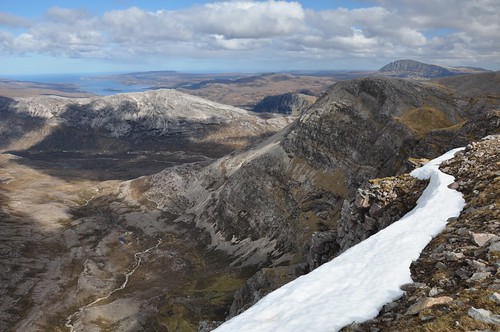
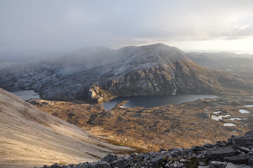
The clouds had now closed in a bit and things had turned a bit grey but although strong the wind was somewhat less than experienced lower down.
Loch an Easian Uaine from Arkle
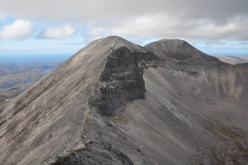
Even though some of the light had gone the rocky architecture on the ridge and lining the corries walls was superb. A narrow ridge drops down before sweeping around to the north west top and summit. Nearing the main top I glanced back over the stepping stones that formed part of this rocky highway.
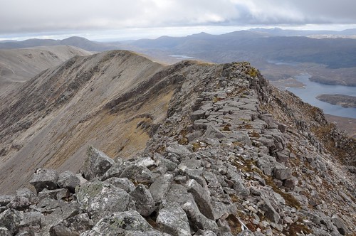
Looking south along Arkle's ridge
Finding relief from the wind behind the cairn I donned my waterproofs to guard against the approaching showers. The many lochans on the moor below caught the light of the lowering sun to provide shards of silver in the rain laden mist.
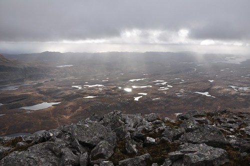
Land of a thousand Lochans
The clouds began to break slightly as I made my return around the ridge to the south.
Arkle's South East top
Keeping a bit closer to the corrie edge I worked my way back over the rocky terrain toward the tent. A pair of Ptarmigan sauntered along in front of me as I tried to take a picture but there was not quite enough light. They eventually took short flight and I thought I was the reason for their hurried departure; but I caught a movement out of the corner of my eye that alerted me to an alternative culprit; a fox quickly scurrying off down the hillside! The last rays of sun splashed the hillside opposite red momentarily and I sat a while taking in the last rays of the day.
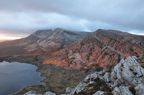
Evening glow in Coir Chruiteir
As the evening colours continued to illuminate the sky the steep slopes of Arkle stood out in dark silhouette.
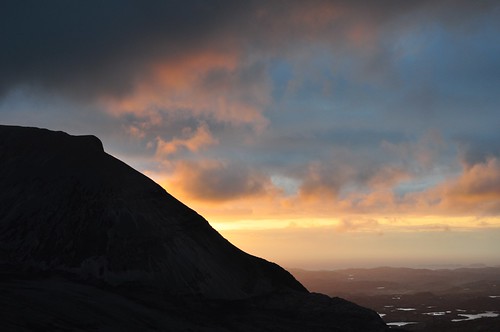
Evening glow in Coir Chruiteir
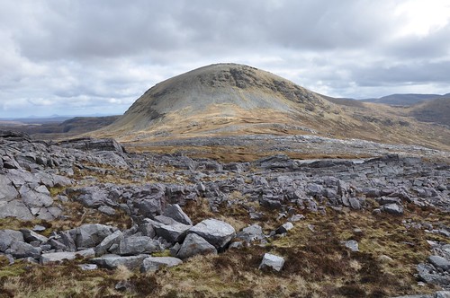
Back at the tent it was time for a quick wash before settling in for my evening meal and a good night's sleep. Rain splashed the tent during the night and early hours competing with the wind to make the most noise. I took my time over breakfast allowing the day to brighten slightly before heading off. Working my way up the hillside behind the tent I made my way over to Bealach Horn and decided to tackle Meall Horn. The north west tip of the hill is rounded and a bit craggy but I had little difficulty working my way up. I tried to keep track of my ascent route so as to ease any potential problems in my return. I was soon standing on top of Creagan Meall Horn before continuing in a south westerly direction toward the main top. I tried and failed miserably to reach the shelter of the cairn before the approaching rain shower arrived. Slightly damp I had a cereal bar while waiting for the rain showers to disperse.
Foinaven from Meall Horn
A couple of Plover seemed unperturbed by the damp weather as they piped a high pitched tune while searching for food. The wind soon dried me as I worked my way back across the first top and then back down through the crags to Bealach Horn.
Looking back at Meall Horn above bealach Horn
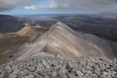
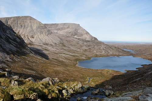
On reaching level ground I headed west to improve my view of Arkle and hopefully the terrain for my climb up to An t-Sail Mhor. Again picking out rock seams and grassy runways I worked my way along the escarpment.
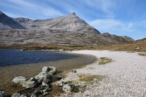
Arkle across Loch an Easian Uaine
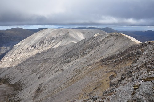
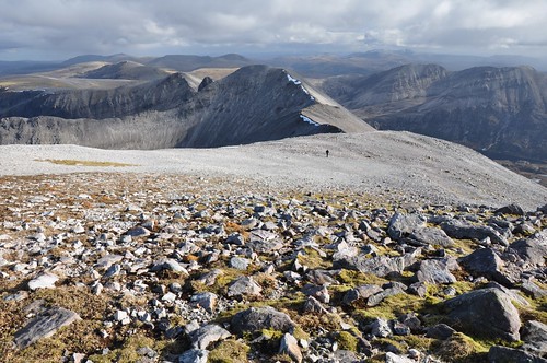
Nearing the top I spotted a number of deer grazing on the open moorland that leads down to Meall Horns northern corrie. Eventually gaining the stony plateau of An t-Sail Mhor I was greeted with glorious views of Foinaven.
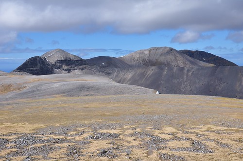
Foinaven from An t-Sail Mhor
The weather had brightened considerably just as I reached the top adding to the fine airy feeling. As I strolled across the stony plateau Ben Hope shone brightly out to the east.
Ben Hope past An t-Sail Mhor
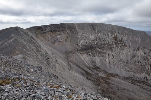
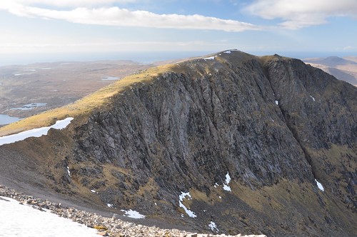
Like its sister Arkle, Foinaven is made up of glistening white Cambrian quartzite. The many spectacular shattered ridges give the appearance that the mountain is crumbling apart. I worked my way toward the cliff edge to take a look into Coire na Lurgainn.
Coire na Lurgainn
Following the cliff edge I worked my around toward the first (808m) of Foinaven's four Tops.
Foinaven from the slopes leading to the first top
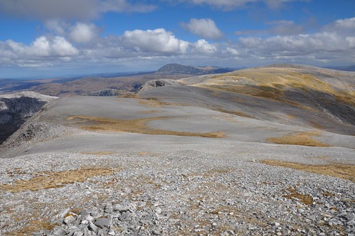
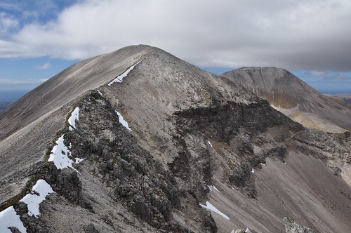
It's a fine walk from here along a slender 3km ridge that ends at the final top of Ceann Garbh. The most awkward part of the route now lay immediately ahead, with a steep descent of around 120m to the col Cadha na Beucaich. I wasn't sure if I could keep to the ridge line so tended over to the left onto loose stones, which proved to be very slippery in places.
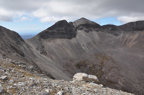
Col Cadha na Beucaich, top 869m and Ganu Mor beyond
From the col it was to be an easier ascent up the steep slopes to climb the prominent rocky tooth. After a little handwork while clambering over the final section of the tooth I could see the way ahead was about to level off.
Top 869m and Ganu Mor
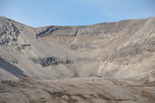
Pausing here I peered down into the rocky caldron of Coire na Lurgainn.
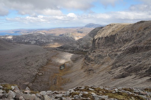
Coire na Lurgainn
After following the slight undulations I was soon on the second top (869m). From the second top the ridge of A' Ch'eir Ghorm stretches east and provides one of the mountains most spectacular features.
A' Ch'eir Ghorm ridge and screes
From here the main ridge drops slightly before curving gracefully round to main top, Ganu Mor.
Last pull to the top; Ganu Mor from the south
A' Ch'eir Ghorm's finest side was now in full view, the ridge pointed out to the east like a giant gnarled finger. The passing showers that had dimmed the skies earlier now added a rainbow to what was already a fine scene.
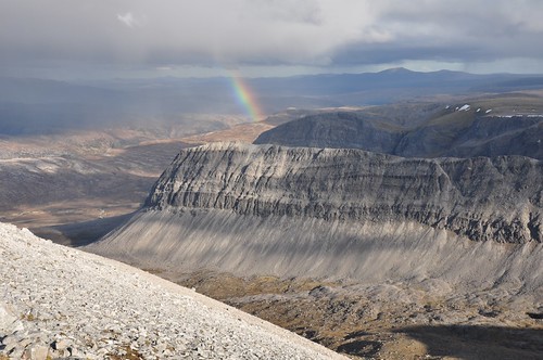
A' Ch'eir Ghorm from Ganu Mor
I met with another walker on Ganu Mhor's short ridge before he headed off across the many quartzite stones showing bright in the strong sunlight.
Walker heads south from Ganu Mor
After a bite to eat the now fine weather encouraged me to continue along the ridge to the final top.
The north end of the ridge; Ceann Garbh from Ganu Mor
As I reached the fourth and final top I could see Cranstackie across Strath Dionard crowned with a small white cloud.
Cranstackie from Ceann Garbh
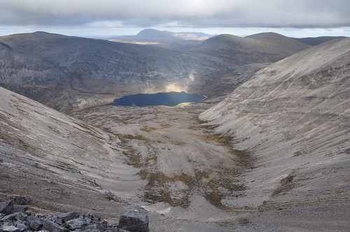
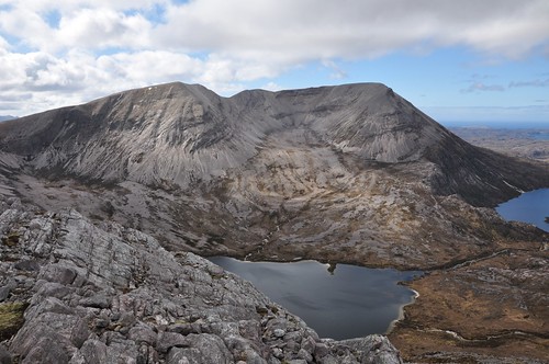
It was now time to work my way back along the ridge and enjoy the views for a second time. I thought it was going to remain clear 'till sunset but the mist rolled in before I got to Cadha na Beucaich. Descending to the col was easier on this northern side and I decided to take a direct line on my ascent on the southern side. After a bit of easy scrambling to get up through the crags near the base it was then just a steep pull to the top. This direct line would have been a more preferable way to get down; just requiring a bit of care as the way steepens near the end. Looking toward An-t-Sail Mhor I noticed that there was a grassy ledge traversing the hillside below the summit. I took this option and it proved a good choice providing a change from the mainly rocky ground covered during the day. The evening light tried to break up the mist as it gathered around the tops, and a brief clearing saw Arkle appear across the loch as a burst of sun struck the hillside.
Arkle and Loch na Tuadh
The sun was starting to go down and appeared in shades of orange through the distant rain showers. It was back across the rock as I negotiated the last of the slopes and it was almost dark as I rounded a last section near the tent. The wind was blowing again so I cooked in the tents vestibule before settling down to sleep; it had been a long day, a 10 hour walkabout. A quick excursion outside the tent during the night and I was standing below a clear night sky which had brought with it a drop in temperature. Poking my head outside in the morning revealed a cloudless blue sky to start the day. I decided to take a circuitous route back to the car by cir-cum navigating around Arkle. After packing I dropped down the hillside following the line of the small waterfall that emanated from the Lochan near my camp site.
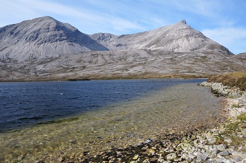
Arkle and Loch an Easian Uaine
Deer tracks helped ease the way as I followed the stream on its course down to Loch an Easian Uaine. As I descended a Meadow Pipit's chirpy song could just be heard above the babbling of the burn.
Foinaven and Loch an Easian Uaine
Ambling along the loch side a nice panorama opened up of Arkle's the eastern flanks. I had grand views into the heart of the scree laden corries of An Garbh-choire and Am Bathaich.
Arkle across Loch an Easian Uaine
An outline high in the corrie wall caught my attention, was it something extra terrestrial?
Is that ET up there?
Arkle's top appeared more conical and grew in stature as I reached the river that links Loch an Easian Uaine to Loch na Tuadh.
Arkle across Loch an Easian Uaine
A Dipper dallied on a rock waiting for a passing meal while a Pied Wagtail fluttered by on its way upstream. Many more Meadow Pipit's were in evidence along the section of river, hopefully making in roads into some of the early season midges. Arkle's character changed on reaching Loch na Tuadh the stony slopes of the corrie replaced by very steep and craggy northern slopes
Arkle across Loch na Tuadh
The route became rougher as the heather increased in size along Loch na Tuadh. The view across to Foinaven revealed many large erratic boulders strewn across the floor of the glen. Nearing the end of the loch a fisherman was trying his luck while enjoying the fresh air and scenery. After a quick chat I left him to cut up onto a good track that took me to a bridge to ford the river at the head of the loch. The walking was a lot easier now especially when the hard surface became softer under a covering of grass. The surrounding countryside was covered with many small lochans that are feature of this part of the world. The track took me gently down the hill and around the northern flanks of Arkle to lead to another Loch. After running along the side of Loch Airigh a' Bhaird the track turned right but I left it hear to follow the eastern shore of Loch an Nighe Leathaid. The rough going returned as I pushed on across the tussocky grass before stopping for lunch half way along the loch. It was very pleasant sitting in the sunshine being cooled by the breeze.
Loch an Nighe Leathaid
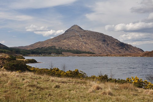
From the loch end I picked up more defined deer tracks as I made a beeline for the small wood near Lone. Squelching along I managed to avoid any of the deeper bog and eventually made the large boulders at the entrance to the wood. After another break I was now ready to complete the outward journey being welcomed back to the start with the now familiar view of Ben Stack.
Ben Stack across Loch Stack
A quick splash about in the stream near the car and I was suitably refreshed and ready for the journey back to Aberdeen.
Ben Stack across Loch More
Top Of Page
site info
© 2007-2008 Paul Sammonds. Template Design by Andreas Viklund.